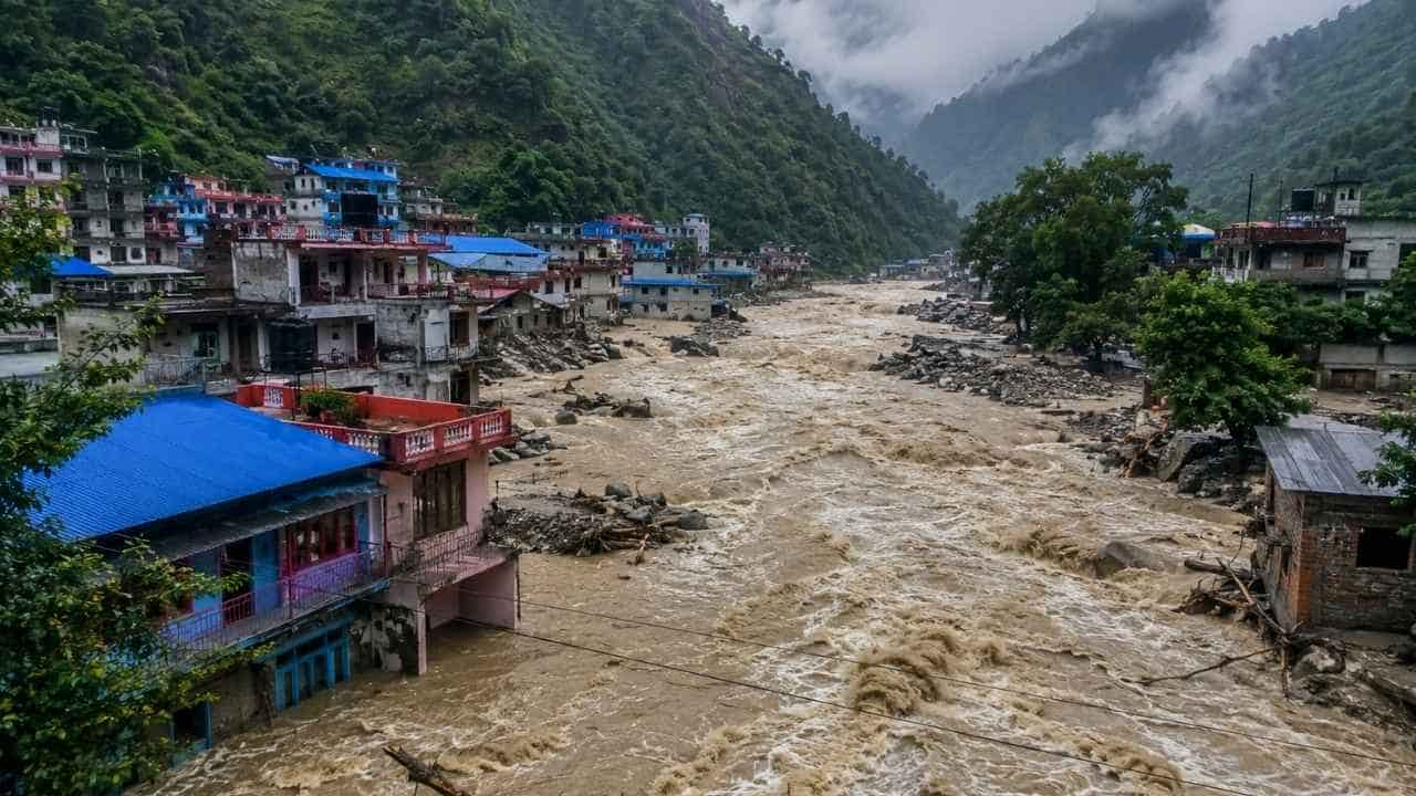
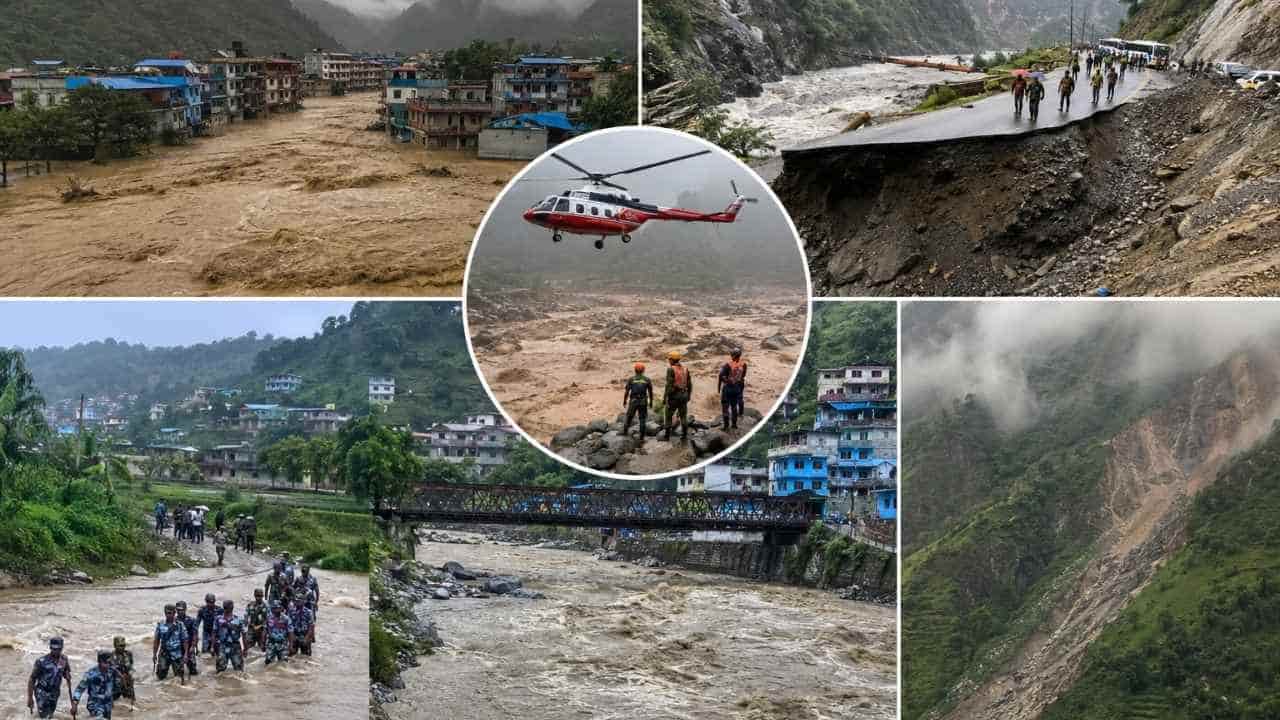
The disaster has caused extensive damage to roads, hydropower projects, settlements and other infrastructure. Rescue teams are still searching for missing people, while road access to several affected areas remains difficult.
The figures are still being updated as rescue teams reach remote locations and authorities identify recovered bodies.
What Happened in Nepal? Nepal floods 2026
The disaster began in the Himalayan region near the Nepal–Tibet border when a glacier collapse and rockfall released a large volume of ice, rock and water.
The resulting flood moved rapidly downstream through the Bhote Koshi system, damaging communities and infrastructure along the river.
The speed and force of the flood left little time for people living and working near the river to respond. Hydropower projects were particularly badly affected because several facilities and work sites are located directly along the river corridor.
The flood also damaged roads and bridges that normally provide access to remote settlements, making the rescue operation more difficult.
Latest Nepal Flood Figures
The latest official figures available on August 31 show the scale of the disaster:
- 903 people have died
- 4,247 people remain missing
- 10,451 people have been rescued
- 267 people have been injured
- More than 20,800 security personnel are involved in rescue and relief work
- 411 helicopter sorties have been carried out
- Foreign nationals are among those still unaccounted for
- 933 people associated with hydropower projects remain among those reported missing
These numbers should not be treated as final. Search operations are still underway, and the authorities continue to revise the figures.
Which Parts of Nepal Are Most Affected?
The main disaster area is concentrated around the Bhote Koshi and Trishuli River corridors.
Rasuwa
Rasuwa is one of the worst-affected districts. The flood damaged settlements, hydropower infrastructure, roads and bridges.
The district is also important for tourism because it provides access toward the Langtang region and the Nepal–China border.
Nuwakot
Nuwakot has suffered extensive damage and has a large number of people still reported missing.
The district sits along important river and road corridors connecting northern areas with central Nepal, so damage here has consequences for transportation beyond the immediate flood zone.
Dhading
Flooding and river erosion have damaged sections of important transportation routes in Dhading.
This matters to tourists because the district contains part of the main road connection between Kathmandu and Pokhara.
Chitwan, Gorkha, Nawalparasi and Tanahun
The disaster has also resulted in deaths and damage in these districts. The authorities are continuing search, recovery and relief operations across the wider affected area.
Why Are Hydropower Projects a Major Concern?
Hydropower facilities along the river corridor were hit particularly hard.
Workers at several projects remain unaccounted for, with authorities reporting 933 hydropower-related personnel among those missing.
Some workers may have been inside tunnels when the flood struck. Rescue teams are using heavy machinery, engineering equipment and specialist teams to search these underground areas.
The Nepal Army has been leading several of the tunnel searches, with assistance from experts from neighbouring countries.
The situation varies from project to project. At the Rasuwagadhi Hydropower Project, for example, a rescue team searched the tunnel to its deepest accessible point on August 31 and reported finding no people inside. Search operations elsewhere are continuing.
Rescue and Relief Operations Continue
The Nepal Army, Nepal Police and Armed Police Force are leading the response.
More than 20,800 security personnel have been mobilised. Helicopters are being used to evacuate people from locations where roads are blocked or destroyed.
According to the latest government figures, 252 foreign nationals have been rescued by helicopter, along with thousands of Nepali citizens.
Medical teams have also been sent into affected areas, while food, medicines and other relief materials are being transported to communities cut off by the flood.
What Is the Current Road Situation?
Road access is one of the biggest problems following the flood.
Floodwater and river erosion have damaged sections of major highways and local roads. Landslides have added another layer of difficulty, particularly in steep mountain areas.
The Prithvi Highway, the principal road between Kathmandu and Pokhara, has experienced flood-related disruption in Dhading.
For tourists, this means a road journey that normally takes a predictable amount of time may currently require additional time or a change of route.
Anyone travelling by road in Nepal should confirm the condition of the route on the day of travel rather than relying on an old itinerary.
Is Kathmandu Affected?
Kathmandu is not at the centre of the flood disaster.
The more immediate concern for visitors in Kathmandu is transportation to other parts of the country.
If you are staying in Kathmandu and travelling toward Pokhara, Dhading, Chitwan, Rasuwa or other affected areas, check the road situation before leaving.
There is therefore an important difference between saying “Kathmandu is affected by the disaster” and saying “travel from Kathmandu may be affected by damaged roads.”
Is Pokhara Affected?
Pokhara is outside the main flood-affected corridor.
The city continues to operate as Nepal’s major tourism gateway for the Annapurna region.
The issue for visitors is transportation between Kathmandu and Pokhara. Because sections of the highway have been affected by flooding and landslides, travellers using the road should allow extra time and confirm the latest road conditions.
This does not mean that Pokhara itself has been closed to tourists.
What About Langtang Trek?
Langtang requires particular attention because Rasuwa is one of the districts directly affected by the disaster.
The road toward the Langtang trekking area passes through infrastructure that has been affected by the recent floods and landslides.
For that reason, anyone planning a Langtang Valley Trek should not rely on information published before August 26.
The condition of the road, bridges and trail access needs to be confirmed before travelling toward Syabrubesi and beyond.
At present, Langtang should be treated differently from trekking regions farther away from the disaster zone.
What About Everest Base Camp Trek?
The Everest Base Camp Trek is not located in the main Bhote Koshi–Rasuwa flood zone.
That does not mean every part of an Everest itinerary is automatically unaffected.
Most trekkers traveling to Everest begin with transportation from Kathmandu to the Everest region, and weather can also affect Lukla flights.
If you are planning an Everest Base Camp trek, check:
- Kathmandu–Lukla flight operations
- Weather at Lukla and along the trail
- Current trail conditions
- Local weather forecasts
- Any transportation disruption between your arrival point and Kathmandu
The flood in Rasuwa should not be used as a reason to declare the entire Everest region closed.
What About Annapurna Base Camp and Poon Hill?
The Annapurna region is outside the main flood disaster area.
This includes popular routes such as:
- Annapurna Base Camp Trek
- Ghorepani Poon Hill Trek
- Mardi Himal Trek
- Annapurna Circuit
However, these routes are still in the Himalayan environment during the monsoon season.
Rain can produce local landslides, muddy trails and road disruptions even when a destination is far from the original flood.
For an Annapurna Base Camp Trek or Poon Hill Trek, the current road conditions around Pokhara and the specific trekking route should be checked before departure.
What Does the Flood Mean for Tourists?
The current disaster does not mean that tourism has stopped throughout Nepal.
The situation is different from district to district.
A visitor staying in Kathmandu has a different situation from someone travelling to Rasuwa. A trekker heading to Annapurna has a different set of conditions from someone travelling toward Langtang.
This is why a general statement such as “Nepal is closed” or “Nepal is completely safe” does not give travellers enough information to make a sensible decision.
The destination and route matter.
Can Foreign Tourists Still Travel to Nepal?
Yes, but travellers should check their individual itinerary before travelling.
Foreign visitors are among those affected by the disaster, and the authorities have been working to locate missing foreign nationals and coordinate rescue and information services.
Tourists already in Nepal should stay in contact with their hotel, guide, trekking company or local representative if their plans involve an affected district.
Anyone planning to travel toward Rasuwa or other flood-affected areas should wait for reliable confirmation that the required roads and trails are accessible.
Should You Cancel Your Nepal Trek?
There is no single answer for every trek.
If your itinerary goes directly through a flood-affected area, postponing the trip or changing the route may be necessary.
If you are travelling to a different trekking region, the situation needs to be assessed separately.
For example:
Langtang: Check the latest road and trail access carefully because of its location in Rasuwa.
Everest: Check flights, weather and current trail information.
Annapurna: Check the Kathmandu–Pokhara connection and local trail conditions.
Poon Hill: Check road access to the trekking starting point and current weather.
The safest approach is to make the decision using information from the few days immediately before your trek rather than information from before the flood.
What Should Travelers Check Before Leaving Kathmandu?
Before starting a trek or long road journey, check five things:
Road Condition
Ask for the latest information on the exact road you will use.
Weather
Check the current forecast rather than relying on a forecast from several days earlier.
Trail Condition
A road may be open while a trekking trail or bridge farther ahead is damaged.
Transportation
Confirm domestic flights and road transfers before leaving Kathmandu.
Local Advice
Your guide, trekking agency and accommodation providers can often provide more useful route-specific information than a general national travel update.
Where Can You Check Official Flood Information?
For current river and flood information, travellers can monitor Nepal’s Department of Hydrology and Meteorology (DHM).
DHM provides flood forecasting, river monitoring and weather information, including a River Watch service and flood early-warning information.
Department of Hydrology and Meteorology — Nepal
For people in Nepal, DHM also provides the 1155 toll-free number for weather and flood information.
Why Conditions Can Change Quickly in Nepal
Nepal’s mountain roads and trekking routes are exposed to several hazards during the monsoon.
Heavy rainfall can loosen slopes above a road. River levels can rise quickly. A bridge can become unusable even when the trail on either side remains intact.
After a major flood, there is also the problem of damaged infrastructure that may look passable but has not yet been assessed properly.
For this reason, local route information is particularly valuable when travelling immediately after a natural disaster.
What Happens Next?
The immediate priority remains the search for missing people and the evacuation of communities that are still cut off.
Once the emergency rescue phase is completed, authorities will have to assess damaged roads, bridges, hydropower facilities and public infrastructure.
Some repairs will take days.
Others will take considerably longer.
The final impact will become clearer only after rescue teams and engineers can reach the affected sites and complete their assessments.
Nepal Flood Update: What Travelers Need to Know
The August 26, 2026 flood is a serious regional disaster, not a nationwide closure of Nepal.
The worst impacts are concentrated around the Bhote Koshi–Trishuli corridor, particularly Rasuwa and Nuwakot, with damage extending into other districts.
For tourists, the practical issue is access.
Road conditions can change. Some trekking routes require fresh assessment. Flights can be affected by weather. And destinations located outside the disaster area can still experience transportation problems because they depend on roads passing through affected districts.
If you are planning a Nepal trip, check the specific destination, route and transportation arrangements shortly before travelling.
Do not rely on a general headline to make the decision.
Final Travel Advice
Nepal’s August 2026 flood is a serious emergency, but the conditions in Rasuwa are not the same as conditions in Pokhara, Annapurna or the Everest region.
If you are already in Nepal, follow local instructions and check your route before travelling.
If you are planning a trek, ask for a current update on your exact trail, road connection and flight or transport arrangements.
And if conditions change, be prepared to change your itinerary.
This article was last updated on August 31, 2026 and should be updated again as official casualty figures, road conditions and trekking access information change.